The UK has announced a £27 billion fix for its motorways – this map shows where and when the work is being done

The British government is launching one of the largest road renewal programmes in years, pumping £27 billion into upgrading and future-proofing England’s ageing motorways and major A-roads over the next five years.
The investment focuses heavily on repairing and renewing the strategic road network before major problems emerge. It includes resurfacing more than 9,000 kilometres of motorway and major A-road lanes, nearly a quarter of the entire network, and dedicates £8.4 billion specifically to proactive repairs on motorways and key A-roads.
An additional £7.3 billion has been allocated to local authorities for fixing potholes and longer-term maintenance of local roads.
“This major renewal of ageing English roads will keep the country moving safely and reliably while supporting economic growth,” the Department for Transport said in its announcement.
A massive renewal effort for concrete-era infrastructure
Much of England’s motorway network dates back to the 1960s and 1970s, with sections of concrete carriageway now showing significant wear.
The programme targets full reconstructions on deteriorating stretches, bridge renewals, and junction upgrades to handle modern traffic volumes and heavier vehicles.
Key renewal projects include:
- M180 Junctions 2-3 (Yorkshire): Full reconstruction of ageing concrete road.
- A180 Brocklesby to Barnetby (Lincolnshire): Reconstruction of concrete sections serving major ports at Immingham and Grimsby.
- M62 Goole, Howden and Airmyn (Yorkshire): Refurbishment of two bridges, including protective measures against future damage.
- M6 Lune Gorge (North West): Renewal of ageing bridges built in the late 1960s along a 10km stretch between Junctions 37 and 38.
- M27 J5-7 (South East): Concrete overlay and upgrades to barriers and drainage, expected to extend the road’s life by around 40 years.
- M32 Eastville Viaduct and M5 J19-20 Wynhol Viaduct (South West): Major structural repairs to keep these key routes safe and operational.
The government has also greenlit 16 major schemes for development, ranging from new bypasses and link roads to junction improvements. These are designed to reduce congestion, improve safety, and unlock housing and jobs.
Examples include the A66 Northern Trans-Pennine dualling in the North, the M54 to M6 Link Road in the West Midlands, the A428 Black Cat to Caxton Gibbet dual carriageway in the East, and the A417 missing link in the South West.

Several schemes are already in advanced planning or early construction phases, with more details on timelines expected as construction rolls out.
Interactive map
To help drivers, businesses, and local communities understand the scale and timing of the works, the Department for Transport has published an interactive map showing all RIS3 schemes across England.
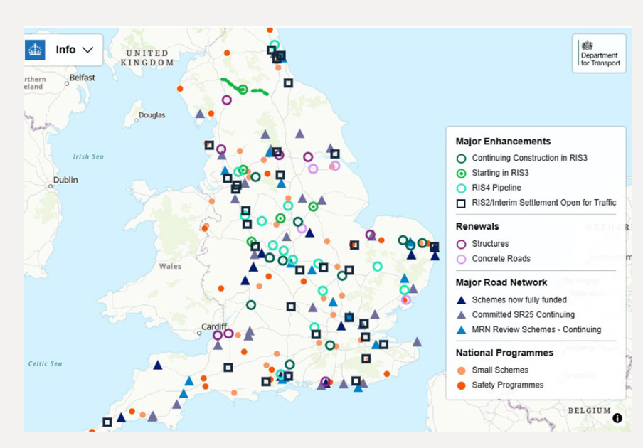
The full interactive map can be found here.
The map highlights locations of resurfacing, reconstructions, bridge works, and new enhancements, with information on expected delivery periods. It allows users to zoom in on specific regions, from the M25 around London to northern routes like the A66, and see how works will be phased to minimise disruption where possible.
National Highways, the government-owned company responsible for the strategic road network, will lead delivery. The programme sets ambitious targets for safety, journey reliability, network condition, and environmental performance.
Economic boost and long-term benefits
Officials say the £27 billion package will support thousands of jobs in construction and related industries while facilitating new homes and economic development in communities nationwide.
By addressing ageing infrastructure proactively, the government aims to reduce future disruptions from emergency repairs, improve reliability for freight and commuters, and better integrate the road network with broader growth plans.